Local trails · Gravel & road rides · Bikepacking adventures
Good rides. Worth making time for.
Some rides begin with a free afternoon. Others begin with a map on the table and a few days cleared on the calendar. Here are a few of our favorites, from town trails and mountain roads around Silver City to a night at the edge of the Gila and longer New Mexico adventures.
Choose an outing that fits your bike, experience, and time. The linked maps and route guides will help you plan the details, and we’re happy to talk through the options before you leave.
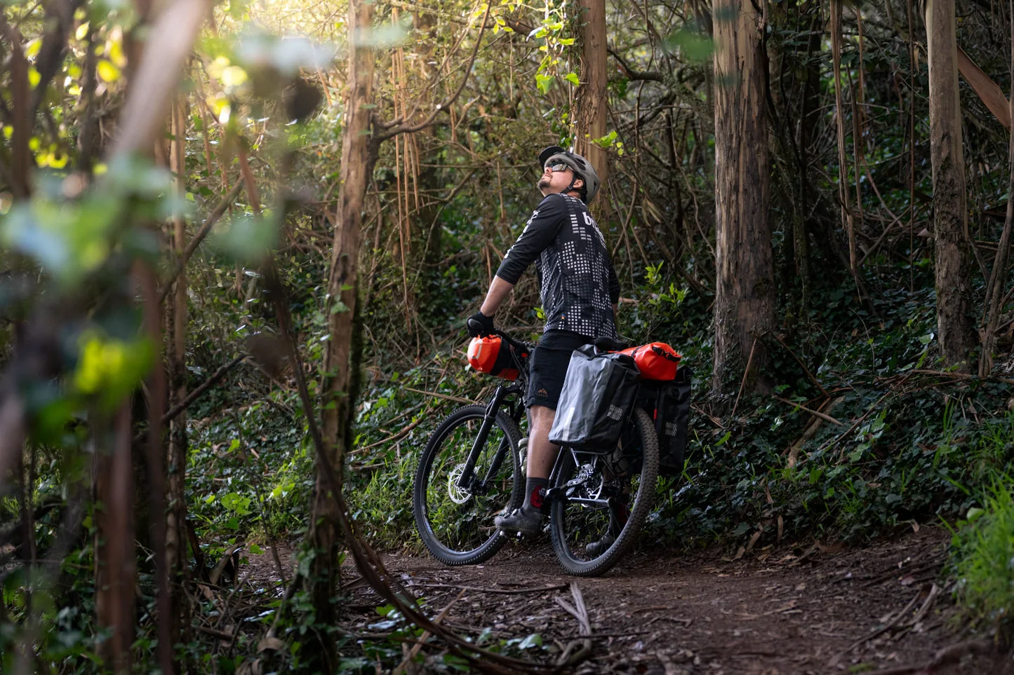
Local rides. No camping gear required.
Start with trails close to town, explore the Fort Bayard network, or make a day of the roads through the mountains. Choose the category that fits the bike and the day you have.
In-town rides.
BOSTON HILL · CLOSE TO TOWN
Boston Hill Blue Loop.
Boston Hill’s Blue Loop puts a trail ride close to town, with room to explore when you have a little extra time. Use the Town of Silver City’s trail information to plan your visit.
The town’s guide describes terrain ranging from flat to moderately rugged, with steep drop-offs and open mining pits. Stay on the trails and choose lines that match your skills.
IN TOWN · SAN VICENTE & THE SOUTHBOUND DIVIDE CONNECTION
San Vicente Trail.
Head south from downtown for creek-side riding on the San Vicente trail system. It’s a convenient way to get outside without a trip to a forest trailhead.
There’s a Divide connection, too: the 2026 Tour Divide update uses the San Vicente RR Grade Trail, rather than the San Vicente Creek Trail. Divide riders should follow the latest official route file; the local trail network and the race alignment are not interchangeable.
Gravel.
Explore our gravel bikes for backroads and mixed-surface riding.
SHEEP CORRAL ROAD · A GRAVEL OPTION
Sheep Corral Road.
For a gravel outing, head to Sheep Corral Road, Forest Road 282, off NM 15 north of Silver City. An out-and-back lets you choose a turnaround that fits the day.
Follow the road, rather than Sheep Corral Canyon Trail #231. Check road conditions and choose tires for the surface. Gravel doesn’t necessarily mean flat.
BEAR MOUNTAIN ROAD · GRAVEL TO LS MESA
Bear Mountain Road to LS Mesa.
For a gravel ride out into the Gila, follow Bear Mountain Road all the way to LS Mesa, then return the way you came. Stay on the road for this outing, rather than turning onto the CDT for the overnight loop.
The local access guide notes that Bear Mountain Road turns to gravel at the National Forest boundary and can be slippery when wet. Check conditions and leave time for the return.
SOUTH OF TOWN · THE DIVIDE CONNECTION
Ridge Road and the Divide connection.
Ride out from town on Cooper Street, which becomes Ridge Road when it crosses Highway 90. For a shorter start that skips the Cooper Street climb, park at the cemetery on Cooper Street and begin there.
The 2026 Tour Divide track uses Ridge Road south of town, turns right onto Tyrone Ridge Road, and follows connecting roads back to Highway 90 before Separ Road. OpenStreetMap labels the final approach Phelps Dodge Mine Road.
Choose a turnaround on Ridge Road for a shorter out-and-back, or plan the full connection using the route file. Looping back to town on Highway 90 adds highway riding to the outing.
Paved-road rides.
NM 15 · A FLEXIBLE PAVED OUT-AND-BACK
Silver City to Pinos Altos.
Head toward Pinos Altos on NM 15 for a paved out-and-back with a destination. The local cycling guide describes the approach from Silver City as a two-lane road with shoulders.
Beyond Pinos Altos, the road guide describes narrower, winding pavement with blind curves and sections without shoulders or center markings. Plan a turnaround that suits your comfort with the road and traffic.
HIGHWAY 90 · TOUR OF THE GILA ROADS
Tyrone and the time-trial climb.
Ride south from town on Highway 90 through Tyrone and continue up the climb used by the Tour of the Gila’s Tyrone Individual Time Trial, Stage 1 in 2026. Make it an out-and-back, with a turnaround that leaves you enough energy for the ride home.
The broad shoulder is a welcome feature, but this is still an active highway. Wear bright colors and use a daylight-visible taillight. Stay alert to traffic and changing shoulder conditions rather than treating the shoulder as a separated bike lane.
THE INNER LOOP · TOUR OF THE GILA ROADS
The Inner Loop.
Known locally as the Inner Loop, this substantial paved circuit follows the Trail of the Mountain Spirits roads, linking NM 15, NM 35, NM 152, and US 180 through Pinos Altos, the Lake Roberts area, and the Mimbres Valley.
Choose your direction: clockwise brings the Sapillo descent; counterclockwise brings the Sapillo climb. These roads feature in two Tour of the Gila stages: in the 2026 race guide, Stage 3 rides clockwise and Stage 5 takes the shared roads counterclockwise, with different starts, finishes, and additional sections.
The road descriptions include mountain climbs, steep winding descents, narrow shoulderless sections, and busier highway riding. Allow time and energy for the full loop, and choose the direction that suits your descending skills and comfort with traffic.
NM 15 · A ONE-WAY ROAD ADVENTURE
Gila Hot Springs. Ride there. Soak. Catch a ride home.
Follow NM 15 north from Silver City through Pinos Altos and the mountains to Gila Hot Springs Campground. Meet a friend for a soak, then catch a ride home without retracing every climb.
This is a substantial mountain-road day. The National Park Service describes NM 15 as steep, narrow, and twisting, with sections lacking a center line. Prepare for the climbing, descents, traffic, and mountain weather.
Pack a swimsuit and towel, and check the campground’s current day-use details and payment requirements; it currently accepts cash or check. Arrange the pickup time, meeting place, and space for your bike before leaving town.
Mountain-bike outings.
Explore our mountain bikes, from hardtails to full-suspension options.
LITTLE WALNUT / GOMEZ PEAK · DAY-RIDE LOOPS
Little Walnut / Gomez Peak.
Explore the interconnected Little Walnut / Gomez Peak network for a day on the trails. Signed junctions and CDT connections let you build a shorter outing or a more involved ride.
Choose the individual trails to match your skills. The Forest Service guide recommends riding within your comfort and experience level; a network with lots of choices isn’t the same as an all-beginner network.
ARENAS VALLEY · A LOCAL TRAIL OUTING
Dragonfly Loop.
The Dragonfly Loop Trail #720 starts off Arenas Valley Road and is open to mountain bikes.
The Forest Service guide highlights the petroglyphs and identifies this as day use only, dawn to dusk. Leave the rock art untouched and give other trail users room.
FORT BAYARD · ANOTHER TRAIL CONNECTION
The Watering Hole.
The Watering Hole links the lower Fence Line Trail with the Servis Corral area in the Fort Bayard network. Work it into a ride using a trail map to plan your approach and return.
This is a connecting trail segment, not a complete loop. Carry your own drinking water.
EAST OF THE TREE · THE SHORTER APPROACH
Big Tree. The shorter ride.
The Big Tree is an immense alligator juniper with a trunk more than 18 feet around, according to the Forest Service. It’s a natural landmark worth making the centerpiece of a ride.
For the shorter outing, start at the trailhead east of the tree, ride to Big Tree, and return the way you came. Use the Fort Bayard trail-system map to check the approach and connections.
Allow time for uneven ground and any sections you’d rather walk.
SOUTH OF THE TREE · A LONGER LOOP
Big Tree. The longer loop.
For the longer option, start at the trailhead south of the tree and make Big Tree part of a loop through the Fort Bayard network. Use the trail-system map to choose your approach and return.
The connections you choose determine the distance and terrain. Bring your proposed loop into the shop if you’d like help making it fit your day.
FORT BAYARD · CONNECT THE TRAILS
Cornell Ranch and more Fort Bayard loops.
Cornell Ranch Trail #758 connects Sawmill Wagon Road with Cameron Creek and can form part of a loop toward Big Tree Trail, as shown on the Forest Service’s Fort Bayard map.
The same map includes Woodhaul Wagon Road, Sawmill Wagon Road, and Stevens Ranch. These are pieces of a wider network: choose connections for the length and terrain you want, rather than treating a connector as a complete ride.
SIGNAL PEAK · BIGGER CLIMBS & FOREST DESCENTS
Signal Peak. Earn the descent.
For a bigger mountain-bike day, look toward Signal Peak: climbing, descending, and time among the ponderosas. The Forest Service guide describes high-elevation mixed-conifer forest, summit views, and trail connections.
There’s more to explore around Black Peak and Meadow Creek. The Forest Service guide also identifies connections to the CDT and Tadpole Ridge Trail #232. Plan a specific combination of trails and roads, rather than treating all of these as one marked loop.
Choose the climb and descent to match your skills, carry your water, and leave time for the return. Check current forest alerts before heading up.
BURRO MOUNTAINS · DESERT VIEWS & CDT SINGLETRACK
The CDT in the Burro Mountains.
For a change of landscape, explore the CDT in the Burro Mountains: granite outcrops, desert woodland, and long views across the Chihuahuan Desert. Choose a section using the Burro Peak trailhead or another road crossing.
Carry your water. The Continental Divide Trail Coalition guide notes that water is absent apart from occasional seasonal runoff.
BURRO MOUNTAINS · AN ADVANCED BACKCOUNTRY LOOP
The Burro Enduro.
For a demanding day in the Burros, the Burro Enduro is a longstanding, roughly 17-mile backcountry loop, rather than a modern timed enduro race. Starting at Deadman Canyon, the mapped route uses Copeland Mine Road and the CDT through the Jack’s Peak and Burro Peak area before returning through Deadman Canyon.
The route guide describes steep, rocky climbs, hike-a-bike sections, technical descents, and confusing unsigned road junctions. This is an advanced adventure ride, not a flowing, purpose-built trail loop. Save the route for offline use, carry enough water and supplies for a long day, and check current conditions before heading out.
These are shared trails, not closed bike courses. Ride considerately, avoid damaging muddy trails, and ask about current access and e-bike rules before choosing a route.
FROM THE SHOP · ONE NIGHT OUT
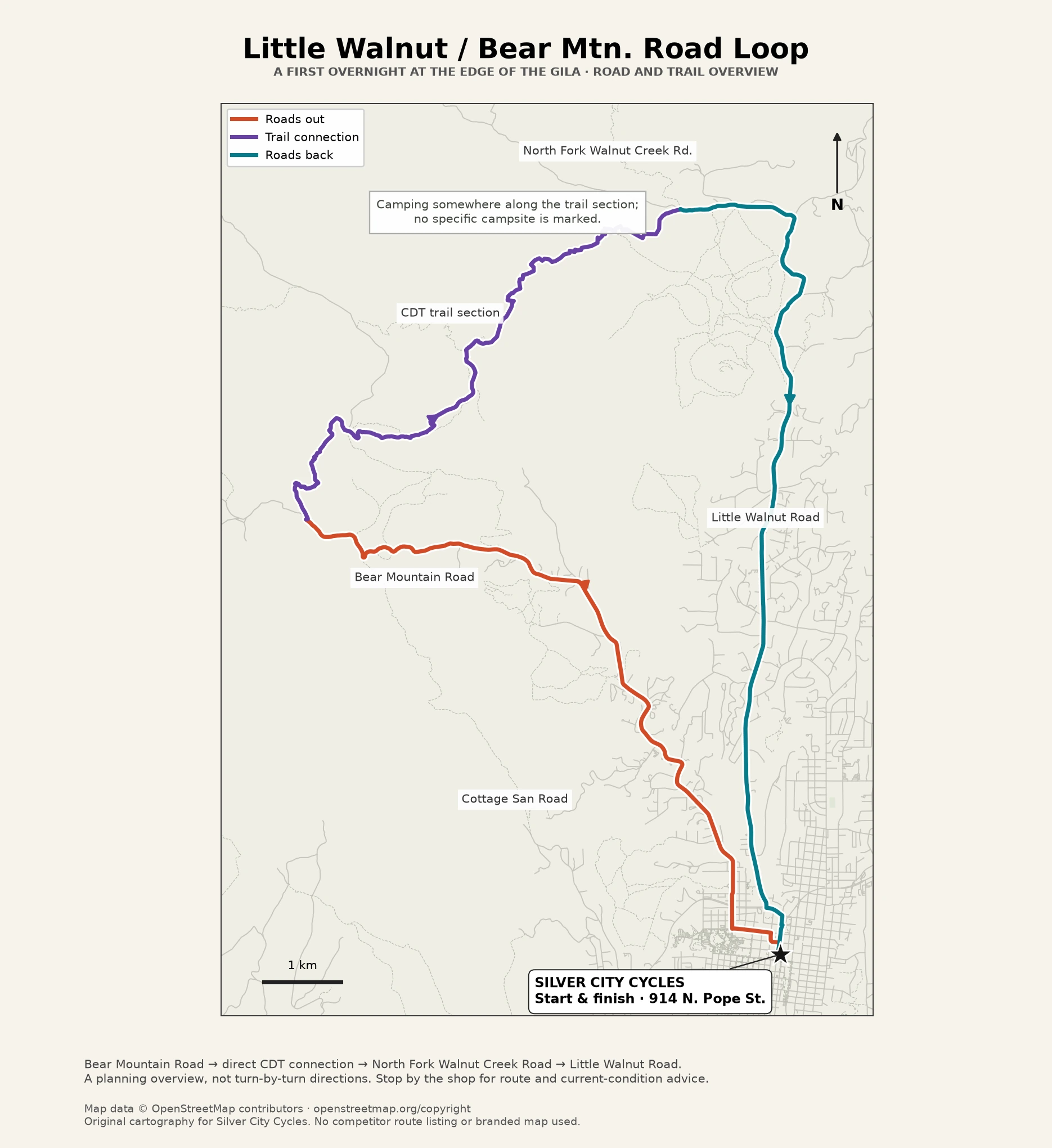
Little Walnut / Bear Mtn. Road overnight.
You don’t have to go far to make a ride feel like a small adventure. Start at Silver City Cycles, head out on Bear Mountain Road, join the CDT directly, and spend a night outside before returning toward town on Little Walnut Road.
The idea is to camp on National Forest land along the trail section between the roads, not at a particular campsite. Give yourself daylight to find a durable spot clear of the trail. There are no toilets, drinking-water facilities, or trash collection at the overnight spot, so bring what you need and leave no trace.
This can be a first bikepacking trip, but it calls for mountain-bike skills. Allow extra time with a loaded bike. Our local overnight guide covers the connections, camping, water, and preparation.
Farther afield. New Mexico bikepacking.
TEXAS & SOUTHERN NEW MEXICO · A DESERT OVERNIGHT
Maar Volcanoes Overnighter.
For a different landscape, the Maar Volcanoes Overnighter makes a roughly 66-mile loop from El Paso into southern New Mexico, visiting Kilbourne Hole and neighboring volcanic craters.
The BIKEPACKING.com route guide links ditch roads, bike paths, rural lanes, and gravel roads, with sand and corrugations in places. It’s a shorter desert trip, but water planning and preparation still matter.
LAS CRUCES & SOUTHERN NEW MEXICO · A BIGGER DESERT TRIP
The Monumental Loop.
For a more demanding multi-day trip, the Monumental Loop explores the country around Las Cruces and Organ Mountains–Desert Peaks National Monument over desert roads, singletrack, and sandy washes.
Expect rough terrain and desert water logistics. Compare BIKEPACKING.com’s route guide with the expanded Monumental Loop 3.0 on Bikepacking Roots, then plan around the specific version you intend to ride.
SANTA FE TO LAS CRUCES · A LONGER NEW MEXICO JOURNEY
New Mexico Off-Road Runner.
The New Mexico Off-Road Runner connects Santa Fe with Las Cruces over roughly 500 miles of dirt, gravel, desert tracks, and pavement.
Broadly following the Rio Grande corridor, the route takes in mountains, high plains, national forest, and southern levee roads and two-track. Plan for cold nights, exposed desert, rough or sandy stretches, and roads affected by wet weather.
A good ride starts before you leave.
Before you leave, read the linked route guides, confirm access and closures, check the forecast, and plan water and resupply. Save navigation for offline use, carry repair essentials, and tell someone where you’re going and when you expect to return. Treat the maps here as planning aids, and check current conditions before committing to a route.
You don’t need the most expensive bike in the shop to have a worthwhile trip. You do need a suitable setup, room for the essentials, and a plan that matches your experience.
Bring your route and questions into the shop. Our Bikepacking page covers bikes, bags, and first-trip preparation; our Service page covers getting the bike ready. We can help you work out the practical details.
Silver City Cycles · 914 N. Pope St., Silver City, NM 88061.
Route planning, practical gear advice, and a little help getting out the door.